Indonesian indigenous groups fight climate change with GPS mapping
BANGKOK: Indigenous communities in Indonesia are using GPS technology to demarcate the boundaries of their ancestral lands, a move many believe could also help mitigate the negative effects of climate change.
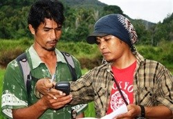
Millions of hectares of customary land are being mapped. Photo: Courtesy of AMAN
"Community mapmaking has been a successful tool to show the government that we are here, and that we want to protect our lands," said Rukka Sombolinggi, a spokesperson for the Indigenous Peoples' Alliance of the Archipelago (AMAN), a Jakarta-based secretariat representing more than 100 indigenous communities.
Indonesia's dense forests are home to an estimated 50-70 million indigenous people, and 10 percent of all known plant species, according to AMAN and the Rainforest Action Network, a non-profit international environmental advocacy group headquartered in San Francisco.
Read the full article on www.irinnews.org.