These mega-quakes spring mostly from regions where fractures on the sea floor intersect with subduction zones, or zones where one slab of Earth's crust is diving slowly under another, they said.
The evidence is statistical and is taken from data from 1,500 earthquakes.
Over the past century, half of the 50 largest earthquakes with a magnitude of 8.4 or more have occurred at these dangerous intersections, the scientists said.
The rate rises to 87% for the 15 biggest quakes above 8.6 magnitude, including behemoths that have shaken Chile and Alaska.
Subduction zones are well known for creating very powerful earthquakes.
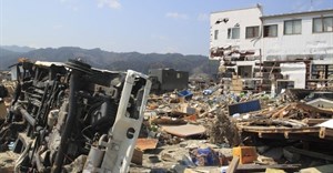
Some regions are notorious, such as the Sunda Trench off Indonesia, which spawned the 9.1-magnitude Indian Ocean quake and tsunami of December 2004.
Others, though, are not picked up as potential threats, as they only generate powerful earthquakes every few centuries or even millennia.
Such long periods are called "supercycles" and because they last happened so long ago, they are not documented in human history.
The worrisome intersections are points where fractures, caused by the movement of ridges on the ocean floor, cross with a subduction zone at a boundary on Earth's tectonic plates.
Why these meeting points become hotspots is unclear.
One theory is that the complex fractures act as a brake, preventing the slow subduction movement. As a result, the stress accumulates over very long periods until it is released catastrophically.
"Even though we don't fully understand the physics of long earthquake cycles, any improvements that can be made using statistical data analysis should be considered, as they can help reduce earthquake damage and loss of life," said seismologist Dietmar Mueller at the University of Sydney in Australia.
The new map is published in the journal Solid Earth by the European Geosciences Union (EGU).
Source: AFP via I-Net Bridge

For more than two decades, I-Net Bridge has been one of South Africa’s preferred electronic providers of innovative solutions, data of the highest calibre, reliable platforms and excellent supporting systems. Our products include workstations, web applications and data feeds packaged with in-depth news and powerful analytical tools empowering clients to make meaningful decisions.
We pride ourselves on our wide variety of in-house skills, encompassing multiple platforms and applications. These skills enable us to not only function as a first class facility, but also design, implement and support all our client needs at a level that confirms I-Net Bridge a leader in its field.
Go to: http://www.inet.co.za